A Conflation and Data Integrity Management Solution
Data Integrity and land base accuracy are the key factors for effective use of GIS applications. In addition, a sanitized data can be properly leveraged for applications requiring higher levels of accuracy (work management, GPS, mobile/field, routing/navigation), as well as improve the day to day operational efficiencies of design and engineering.
Data Integrity for safety and regulatory requirements:
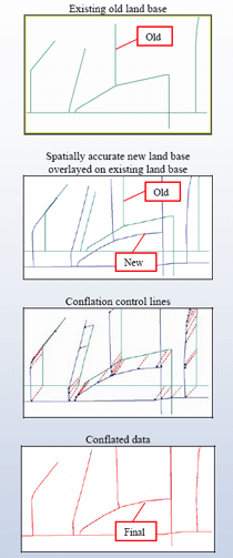
There is a need to improve the geo-spatial accuracy of the land base and other facility data of utilities. Cadsys brings a comprehensive solution to address this need, using its proprietary conflation tool. Our proven data conflation software solution enables utilities to align existing data with a new and more spatially accurate land base source. Cadsys specializes in providing highly accurate conflation and realignment solutions at substantially low costs, and thereby meeting the geospatial needs of organizations of varied strengths.
Cadsys has developed conflation software i.e. Concord-ProTM a conflation and data integrity management solution for all GIS & Mapping Services.

